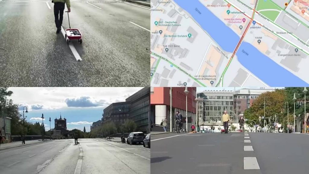
99 Smartphones Used To Create Virtual Traffic Jams In Google Maps
Globally, there is a sizeable number of drivers who will never leave their offices or homes without first finding out about the traffic situation on the routes they plan to use. That is why Google Maps is an almost indispensable tool for such drivers – at a glance, they can instantly tell the roads to use and the ones to avoid.
Since Google Maps collects and relays traffic data in real-time, time-conscious road users are heavily dependent on it. The ability to provide the latest and most reliable info could easily be considered the strongest point of Google Maps.
Interestingly, however, it is this very same strength that performance artist, Simon Weckert has used to fool Google Maps and to create a virtual traffic jam on the streets of Berlin.
Streets Marked Red When They Should Be Green
Just like the traffic lights that we see on the roads, Google Maps uses the colors green, yellow, and red to alert users about the situations in the streets. Should you see a road marked green on your Google Map, it indicates that the road is clear. Ideally, this is the kind of road you should use if you want to avoid traffic snarl-ups. Yellow means that there’s some traffic, and it is slow-moving while red tells you that the road is congested to the point of creating a real gridlock.
Weckert’s Stunt
To create the virtual traffic jam that he did, Simon Weckert must have known something that some people might not know – how Google Maps gets the info it relays. The biggest source of the info that eventually gets used on Google Maps is the consumer. Users of Android and Apple phones who turn on their Location Services function enable Google to know their exact location. Google therefore knows not only the street you are on but also the speed at which you are moving. That is what then makes it possible to tell whether a street is clear or congested.
Apart from real-time data, Google Maps has also built traffic histories and, except for unusual and rare incidents, it can predict with high accuracy how the traffic situation will be on a particular road, on a certain day and at a specific time.
To fool Google Maps, artist Weckert loaded a cart with 99 used smartphones and started wheeling the cart around the streets of Berlin. Since the smartphones had their Location Services on, the message sent to Google Maps was that there was an unusually high concentration of traffic on the streets. Since the cart was being wheeled deliberately slowly, Google Maps was made to believe that the roads in question were full of traffic moving at snail pace. The result? Ways that were empty and should have been marked green on the navigation app were suddenly marked red.
While there are skeptics who doubt whether Weckert’s stunt worked, a spokesman from Google has commented to say that what the artist did is possible. So even the tech giants can be fooled?
Google has promised to make Google Maps even better and more accurate, citing that they are encouraged to see creative uses of their application.
Read more Android articles here.
Latest posts by Campad Electronics (see all)
- Create a Wireless Charging Surface at Home for Less Than $50 - July 9, 2024
- Meet The Telstra 5G Hotspot - May 22, 2024
- Bringing the Future to the Past: Galaxy AI Features Roll Out to Samsung’s Last-Gen Phones - April 15, 2024

 Follow


